
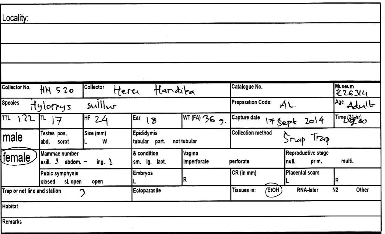
The paper catalog writes the locality once at the top of a sheet and leaves it blank on the sheets that follow. Anyone who reads a later sheet has to assume it belongs to the last locality written. For the specimens from Pasir Putih, that assumption is wrong.
This is the top of the sheet that holds HH 520–523. HH 520 was caught on Line 3 at Pasir Putih, across the lake from Pondok Merah, yet the Locality lines are empty:
In NAHPU, a site is a place you enter once and reuse: a camp, a trap line, a pitfall line. Specimens never carry the locality themselves. They link to an event, and the event links to its site, so every specimen gets the right place without anyone writing it again.
1. Plan the sites
Section titled “1. Plan the sites”The journal describes five lines. Line 1 mixed pitfalls and snap traps, so it becomes two sites, one per method. Add the camp at Pondok Merah, where the team slept, prepared specimens, and wrote the journal, and that gives seven sites. The Site IDs follow the NAHPU convention: a two-letter locality code (TJ for Tujuh), then CAMP and its number for a camp, or the line leader's initials, L for a trap line or P for a pitfall line, and the line number from the paper.
| Site ID | Paper name | Area | What was set | Leader |
|---|---|---|---|---|
TJ-CAMP1 | Not named | Pondok Merah | The camp beside the lake | Heru Handika |
TJHH-L1 | Line 1 | Pondok Merah | 31 snap traps | Heru Handika |
TJHH-P1 | Line 1 | Pondok Merah | 10 pitfalls, about 50 m from camp | Heru Handika |
TJBS-L2 | Line 2 | Pondok Merah | 25 snap traps, most 1–2 m above ground | Bima Sampel |
TJHH-L3 | Line 3 | Pasir Putih | 20 snap traps | Heru Handika |
TJHH-P4 | Line 4 | Pasir Putih | Pitfalls, number not recorded | Heru Handika |
TJHH-L5 | Line 5 | Pasir Putih | 20 snap traps, many on lianas | Heru Handika |
Keeping the paper's line numbers in the Site IDs lets anyone check a NAHPU record against the paper form.
2. Create the first site
Section titled “2. Create the first site”Open Sites and select
+.Enter the Site ID
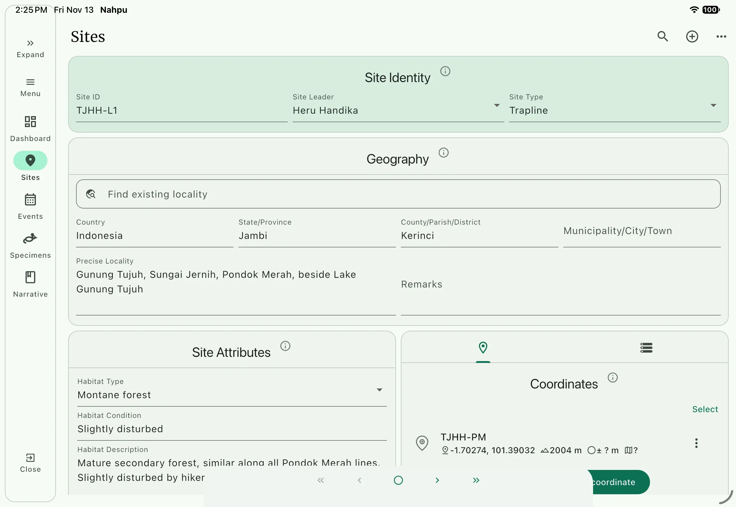
TJHH-L1, chooseHeru HandikaasSite Leader, and choose aSite Typefor a trap line.Enter the geography from the paper header:
Field Value CountryIndonesiaState/ProvinceJambiCounty/Parish/DistrictKerinciPrecise LocalityGunung Tujuh, Sungai Jernih, Pondok Merah, beside Lake Gunung TujuhThe paper writes
Mt. Tujuh. Write the full local name, Gunung Tujuh, so the locality reads the same as the gazetteer. Leave fields you cannot verify, such asMunicipality/City/Town, empty.Enter the habitat. The only habitat on the paper is on HH 436:
Mature secondary forest. The journal for 12 September adds that the forest is similar along all Pondok Merah lines and slightly disturbed by hikers.Field Value Type Montane forestCondition Slightly disturbedDescription Mature secondary forest, similar along all Pondok Merah lines. Slightly disturbed by hikers.Type and condition come from lists in
Settings; add a value there if it is missing.Habitat describes a place, not an animal. Entered here, it applies to every specimen from the line, not just the one specimen whose form happened to have it filled in.
3. Add the coordinate
Section titled “3. Add the coordinate”The paper header gives one point for all of Pondok Merah:
01.70274° S 101.39032° E Elev. 2004 mBefore you enter it, make three corrections:
- Sign. Decimal degrees show the hemisphere with a sign, not a letter. South is negative, so the latitude is
-1.70274. Dropping theSwould move the point to the northern hemisphere, about 380 km away. - Unit. On the first sheet the unit is crossed out (
feetchanged tom); the second sheet saysm asl. NAHPU stores elevation in meters, so enter2004with no unit to argue about. - What is missing. The paper has no datum and no GPS uncertainty. Do not invent them. Keep the default datum only if you know the GPS used WGS84, and leave the uncertainty empty.
On the site page, open the coordinate panel and select
Add coordinate.Choose decimal degrees (
DD) as the format and enter the values:Field Value Name TJHH-PMDecimal latitude -1.70274Decimal longitude 101.39032Elevation 2004Notes One point recorded for all Pondok Merah lines in the 2014 paper catalog. Datum and uncertainty not recorded.Select
Add, then check the point on the map. It should sit beside Lake Gunung Tujuh.
The finished site, with the paper coordinate. The datum and uncertainty show ? because the paper did not record them:
4. Create the other Pondok Merah sites
Section titled “4. Create the other Pondok Merah sites”- With
TJHH-L1open, chooseDuplicate sitefrom the three-dot menu. - Enter the new Site ID
TJHH-P1and changeSite Typeto a pitfall line. - Add the same coordinate again: duplicating leaves the coordinates empty.
- Repeat for
TJBS-L2, withBima SampelasSite Leader. AddMost snap traps set 1–2 m above the ground.toRemarks. - Repeat for the camp,
TJ-CAMP1, with a campSite Type. Its habitat is the same forest. Narratives link to this site in Basic tutorial 6.
5. Create the Pasir Putih sites
Section titled “5. Create the Pasir Putih sites”Pasir Putih is across the lake, and the journal describes each of its three lines differently. Create them from +, not by duplicating, so no Pondok Merah value is carried over by mistake.
Use the same country, province, and county. Then enter:
| Site ID | Precise Locality | Condition | Description |
|---|---|---|---|
TJHH-L3 | Gunung Tujuh, Pasir Putih, across Lake Gunung Tujuh from Pondok Merah | Undisturbed | Many moss-covered trees 1–2 m in diameter. Open ground with few small plants. One rarely used trail. |
TJHH-P4 | Same as TJHH-L3 | Undisturbed | Open canopy, apparently from natural processes. Dense ground cover; fewer large trees than Line 3. |
TJHH-L5 | Same as TJHH-L3 | Undisturbed | Open in places and closed in others. Many lianas. Moss cover similar to Line 3. |
Use Montane forest as the type for all three.
The paper has no coordinates for Pasir Putih. Leave the coordinate panel empty and add this to each site's Remarks: No coordinates recorded in the 2014 paper catalog. About 1.5 hours by boat across the lake from Pondok Merah.
What you gained over paper
Section titled “What you gained over paper”- Every specimen will get its locality from its site, including the ones on sheets with a blank header.
- Pondok Merah and Pasir Putih are separate places, so their specimens cannot be mixed up.
- Elevation has one unit, latitude has its sign, and missing datum and uncertainty are visible as empty fields, not hidden.
- Habitat is described once per place, from the journal and the one specimen that recorded it.